Overview of Approach
The GDFC [He et al., 2020] focuses on droughts and large-scale floods (both pluvial and fluvial). It builds upon legacy systems developed previously at global [Sheffield and Wood, 2007, 2008] and regional [Sheffield et al., 2014] scales, making use of existing models and datasets, but has been enhanced in the following aspects to provide better estimates of the global terrestrial hydrological cycle and its extremes [Figure 1]. We first extend the existing long-term global meteorological dataset (Princeton Global Forcings, PGF, [Sheffield et al., 2006]) from 1950 to 2016, which is also enhanced in its spatial resolution (0.25°) through statistical downscaling and corrected for temporal and spatial inconsistencies. This new version (v3) of the PGF is then utilized to drive an updated version of the Variable Infiltration Capacity (VIC, [Liang et al., 1994 , 1996; Cherkauer et al., 2003]) land surface model to obtain an improved estimate of soil moisture and runoff variability that is key to understanding changes in drought and flood (pluvial and fluvial) risk. We also implement a newly developed global routing and hydrodynamic model CaMa-Flood (Catchment-based Macro-scale Floodplain model, [Yamazaki et al., 2011]) to explicitly characterize flood stage (e.g., inundation area and water level) and river discharge. Related hydrological variables (e.g., 3-month accumulative precipitation from the PGFv3 and monthly soil moisture simulated from VIC) are then transformed to standardized indices. Given the dynamic nature of hydrologic extremes, a joint spatial-temporal analysis is performed to investigate how droughts and pluvials propagate, merge (two events merging into one) or break up (an event splitting into two or more events separated in space) through time and space. We utilize a Severity-Area-Duration (SAD, [Andreadis et al., 2005; Sheffield et al., 2009; Zhan et al., 2016]) clustering algorithm to identify spatially contiguous drought and pluvial events over six continents (excluding Antarctica) and examine the stationarity of their evolution through the estimation of their time-varying frequency. Characteristics (i.e., frequency, spatial extent, severity) of drought and pluvial events (and their associated flooding) are synthesized into a catalogue with a particular focus on characterizing the long-term variability in risk from both a univariate and multivariate perspective.
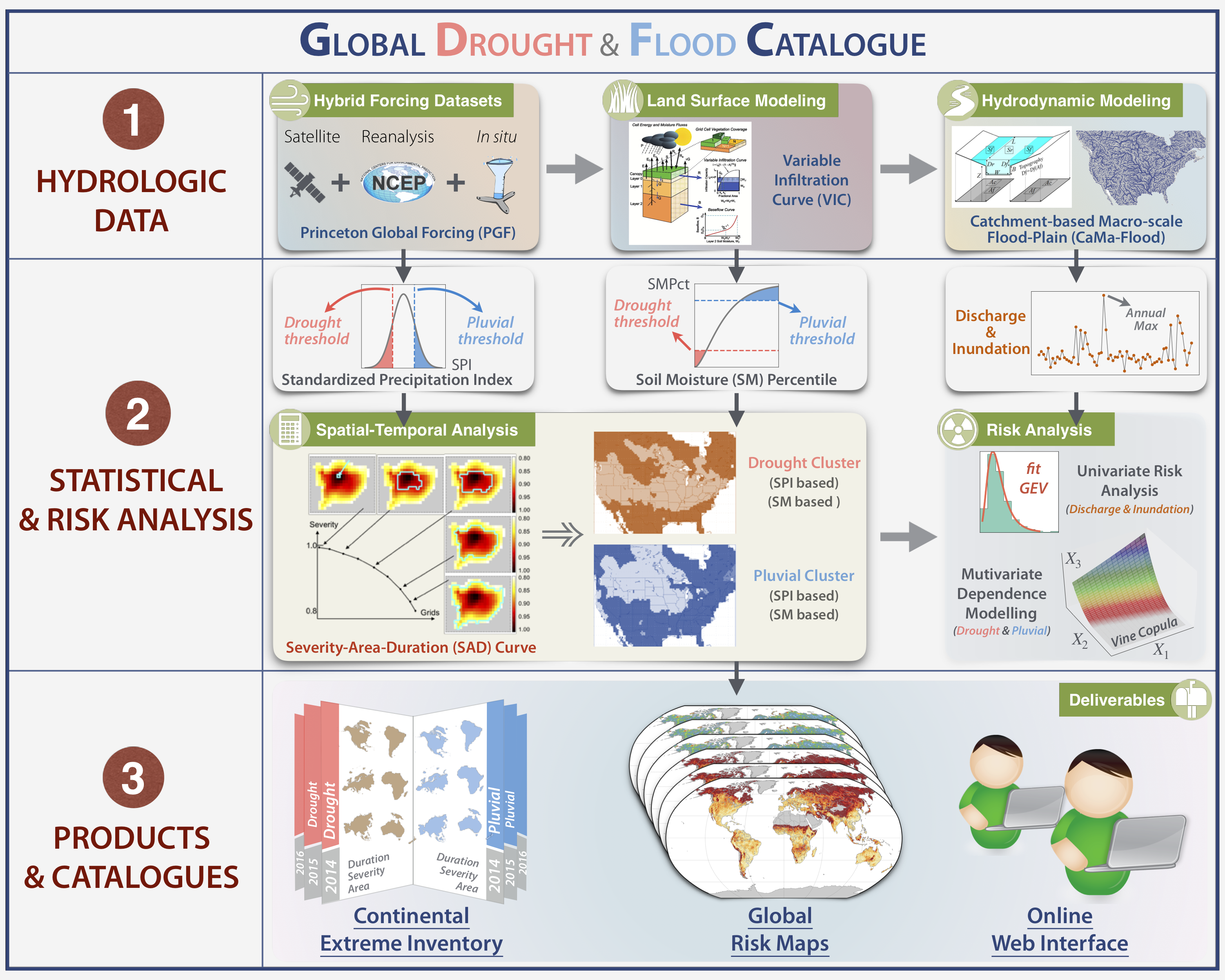
Figure 1. Schematic of the overall framework illustrating three major steps to develop the Global Drought and Flood Catalogue (GDFC). (1) Generating long-term and consistent hydrologic datasets using state-of-the-art physically-based hydrologic modeling platform which includes hybrid meteorological forcings (PGFv3), improved land surface modeling (VIC), and enhanced hydrodynamic model (CaMa-Flood). (2) Robust quantification of drought and flood/pluvial risk based on a suite of statistical post-processing procedures, including the statistical transformation of hydrologic data into standardized indices for drought and large-scale flood identification, spatial and temporal clustering analysis, univariate risk analysis and multivariate dependence modeling. (3) Developing a meta-database to deliver products and catalogues (e.g., drought and pluvial inventory at the continental scale, global risk maps for different types of hydrological extremes, and an online web portal) which enables dissemination of knowledge and data to the wider scientific community. See He et al. (2020) for details.